Plate Boundaries — Print · Grade 9 Science
Chapter: Earth’s Interior & Plate TectonicsPlate Boundaries
Learning goals
- I can identify divergent, convergent, and transform plate boundaries from a description or diagram.
- I can distinguish the three types of convergent boundaries and predict what landform each one creates.
- I can explain why earthquakes and volcanoes cluster along plate boundaries.
Readings for this unit
Before this unit
Describe convergence, divergence and sliding motion.
Plan three teaching sessions: core explanation and Parts 1–2; Parts 3–4 with diagrams and reasoning checks; then the whole-unit application, worked examples, independent practice, and exit check. Read one part at a time, explain it without notes, and revisit any gap. Allow about 40–50 minutes per session; adjust after checking understanding. Trace and explain the labeled figures in each part. In the third session, complete the illustrated case and changed independent application; retain a corrected explanation rather than only an answer.
Start with something to explain
How can two east-moving plates still collide?
Illustrative evidence case. Two hypothetical stations move east at 5 and 2 cm/year. A separate ridge model has youngest crust at the center and older crust on both sides.
Notice and wonder
Record two observations using the stated quantities or relationships. Keep observations separate from possible causes. Write one question that a new measurement could help answer.
How can two east-moving plates still collide?
Your first model
Draw station velocities in a common frame, then show how separation changes.
Build the language from the idea
- divergent boundary
- A place where two tectonic plates move apart, allowing magma to rise and form new crust, as at a mid-ocean ridge.
- convergent boundary
- A place where two tectonic plates move toward each other and collide.
- transform boundary
- A place where two tectonic plates slide horizontally past each other without much crust being created or destroyed.
- subduction
- The process by which a denser tectonic plate sinks beneath a less dense plate at a convergent boundary.
Earth’s lithosphere is divided into large and smaller plates that commonly move a few centimeters per year. Their motion involves interacting processes including sinking cold, dense slabs, gravitational effects associated with elevated ridges, and mantle flow. The mantle is mostly solid but deforms slowly; plates do not float on a global liquid ocean. The relative motion of neighboring plates defines divergent, convergent and transform boundaries.
At a divergent boundary, plates move apart. Rising hot mantle experiences reduced pressure, which can permit partial melting; magma can rise and cool to form new oceanic crust. Mid-ocean ridges record this process. Continental rifting can stretch and thin lithosphere, and some rifts develop into ocean basins. Not every rift has identical history or must complete that transition.
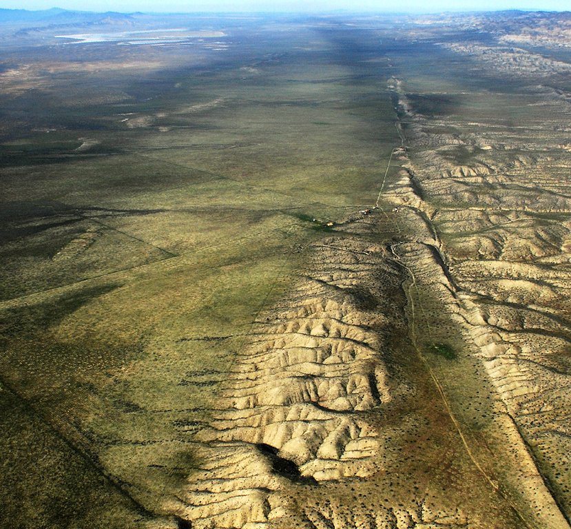
At a transform boundary, plates neither pull apart nor collide — they grind sideways past each other, like two crowded lines of traffic scraping side mirrors in slow motion. Because the rough edges snag and then suddenly lurch free, transform boundaries are famous for earthquakes; California's San Andreas Fault, where the Pacific Plate slides past the North American Plate, is the classic example. But since no crust is being created or destroyed here, transform boundaries build very few volcanoes — a handy clue when you're trying to tell the boundary types apart.
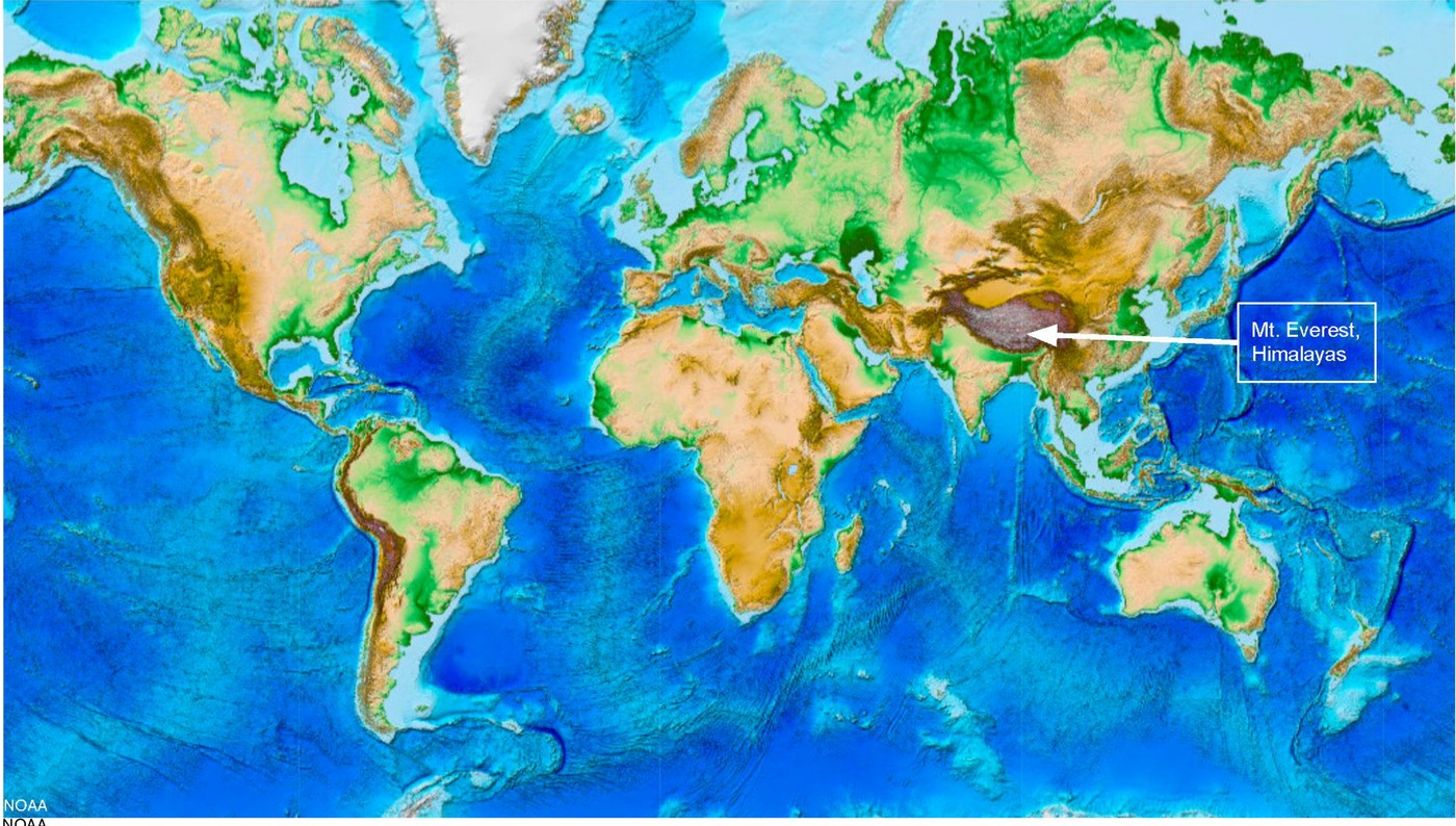
At a convergent boundary, the outcome depends on lithosphere properties, geometry and motion. Cold, dense oceanic lithosphere can subduct, producing a trench and a pattern of deepening earthquakes. Water released from the slab can promote partial melting in the overlying mantle; rising magma can support a volcanic arc. Two oceanic plates can form an island-arc setting. Continental collision commonly thickens crust and builds mountains, as in the Himalayan region; it is not the same as ordinary oceanic subduction.
One idea worth correcting: the plates are not sliding around on a layer of empty space or open liquid — they ride on the solid but slowly flowing rock of the mantle beneath them, pushed and pulled by that convection. Once you can picture the three boundary types, a pattern jumps out of any world map: almost every major earthquake and nearly every active volcano lines up along these plate edges, because that is precisely where all the pulling, grinding, colliding, and melting is concentrated. Learning to recognize the boundaries is really learning to predict where — and why — Earth's most dramatic events happen.
A plate includes crust and rigid upper mantle. At divergent boundaries plates separate and new oceanic crust can form. At convergent boundaries, subduction or continent collision depends on the materials involved. At transform boundaries plates move sideways relative to each other.
Many earthquakes and volcanoes cluster near plate boundaries, but the exact pattern depends on boundary type. Deep earthquakes are associated with subducting plates, while transform boundaries need not have a chain of volcanoes. Use both location and depth data in a comparison.
Plate movement is driven by interacting processes including the sinking of cold dense slabs and mantle circulation. A simple conveyor-belt drawing leaves out differences in viscosity, geometry and forces. Use it to visualize motion without treating it as a complete explanation of all plate behavior.
Build your understanding
Plan three teaching sessions: core explanation and Parts 1–2; Parts 3–4 with diagrams and reasoning checks; then the whole-unit application, worked examples, independent practice, and exit check. Read one part at a time, explain it without notes, and revisit any gap. Allow about 40–50 minutes per session; adjust after checking understanding.
Part 1 · Identify relative motion before landforms
Relative motion compares one object’s motion with another object rather than with a fixed map alone. Two plates can both move east, yet close their separation if the western plate moves faster. For example, west plate 5 cm/year east and east plate 2 cm/year east give closing speed 3 cm/year. Direction arrows must use the same reference frame before subtraction. Boundary type concerns this local comparison; a whole plate may have different kinds of boundary along different edges.
Read the visual model
Read the gap between adjacent blocks and the direction of each arrow. The transform panel is a top view; the other panels isolate separation or approach rather than entire plate shapes.
What happens to separation when the western plate moves east at 2 cm/year and the eastern plate east at 5 cm/year?
Visual reasoning — after your attempt
Separation increases at 3 cm/year in the stated frame, giving relative divergence rather than convergence.
A boundary describes how adjacent plates move relative to one another. Divergent motion separates them; convergent motion brings them together; transform motion moves them past one another. Arrows require a reference frame. A plate can contain ocean and continent, and one plate can border several different boundary types.
Two eastward-moving plates can converge if the trailing plate moves faster. Decide from relative separation rather than assume that arrows must face opposite directions.
Pause and explain
How can two plates moving east still converge?
Check your reasoning after answering
The western plate can move east faster, decreasing the separation.
Part 2 · Connect divergence to new oceanic lithosphere
At a spreading ridge, mantle rises as plates separate. Falling pressure can allow decompression melting, where some hot rock melts without requiring an extra temperature increase. Melt rises and cools into new oceanic crust. That crust moves away and records time since formation. In the supplied model, 120 km in 6 million years is 20 km per million years, equivalent to 2 cm/year for each side. The full plate-separation rate is twice this half-spreading rate if both sides move symmetrically.
Read the visual model
The graph has its youngest point at the ridge and older ages on both sides. Negative distance means the opposite side of the ridge, not a negative rock age.
If each side continues at 2 cm/year, what is the full separation rate, and what assumption matters?
Visual reasoning — after your attempt
It is 4 cm/year under symmetric steady spreading. Real rates and symmetry must be tested; the supplied age-distance line does not prove a constant rate for all times.
At a spreading ridge, plates separate and hot mantle rises. Reduced pressure can permit partial melting; magma cools to form new oceanic crust. Cooling material moves away, becomes denser, and thickens as lithosphere. Symmetric magnetic patterns and increasing seafloor age provide tests of spreading.
The ridge is commonly elevated because newly formed lithosphere is hot and buoyant. This connects temperature, density and topography; it does not imply that all crust floats on liquid magma.
Pause and explain
What age pattern is expected on opposite sides of a spreading ridge?
Check your reasoning after answering
Youngest seafloor near the ridge and generally older seafloor farther away on both sides.
Part 3 · Distinguish subduction from continental collision
In subduction, relatively cold oceanic lithosphere descends beneath another plate. Minerals within the slab can release water as conditions change. The added water lowers the melting conditions of parts of the overlying hot mantle, allowing partial melting. Magma can rise toward a volcanic arc above the slab. The slab does not need to melt wholesale to explain those volcanoes. An ocean trench, a band of earthquakes deepening beneath a plate and a volcanic arc together provide stronger evidence for this setting than a mountain alone.
Read the visual model
Follow the descending blue slab path, then the upward red magma pathway. These are related processes in different regions rather than one arrow tracing molten slab material.
Would mountains alone uniquely identify subduction? Name a stronger evidence combination.
Visual reasoning — after your attempt
No. A trench, earthquake depths increasing along the descending plate and an appropriately located volcanic arc together support subduction more strongly. Continental collision can also make high mountains.
Cold oceanic lithosphere can descend at a convergent boundary. Released water can promote partial melting in the overlying mantle, supporting a volcanic arc. Continental collision commonly thickens crust and raises mountains; it does not create the same typical oceanic subduction setting in every case.
A trench, volcanic arc and earthquakes deepening inland form a related evidence pattern. A mountain chain alone is less diagnostic because several processes can make high terrain.
Pause and explain
Why is a trench plus deepening earthquake pattern stronger evidence than mountains alone?
Check your reasoning after answering
The combined spatial pattern specifically supports a descending plate; mountains have multiple possible causes.
Part 4 · Explain forces and evaluate a boundary model
A transform boundary connects regions undergoing lateral relative motion. Fault segments can resist sliding through friction while neighboring rock deforms. When slipping occurs, the strain release can produce an earthquake. This explains why a boundary without the typical creation of new crust at a ridge can still be hazardous. Plate motion also responds to slab pull, ridge-related gravity and mantle interactions; no single circular-arrow picture fixes every plate’s behavior. Distinguish the direction of plate movement from whether a particular fault patch is currently locked.
Read the visual model
The two arrows pass the common boundary in opposite directions in a top view. They are not a spreading-ridge cross-section.
Why can a transform fault produce earthquakes without a chain of subduction volcanoes?
Visual reasoning — after your attempt
Locked sections can store elastic strain and release it during slip. That mechanism does not require the water-assisted mantle melting typical of a subduction arc.
Plate motion involves interactions including sinking slabs, gravitational effects at elevated ridges, and mantle flow. Transform faults accommodate lateral displacement without a typical net creation or destruction of lithosphere at that boundary. Real boundaries can be complex and change through time.
A boundary model should predict motion, crustal change and evidence together. Compare those predictions with earthquakes, volcanoes, landforms and measured plate movement instead of naming a type from one surface feature.
Pause and explain
Must a transform boundary have a volcanic chain?
Check your reasoning after answering
No. Lateral fault motion commonly produces earthquakes without the typical subduction or ridge volcanic mechanism.
Apply the whole unit · Classify three evidence patterns
Illustrative locations: A has young seafloor at an elevated ridge; B has a trench and inland-deepening earthquakes; C has offset roads and shallow earthquakes along a lateral fault.
Your task
Classify each boundary, draw relative-motion arrows, explain its lithosphere effect, and identify evidence needed to test your interpretation.
What your response should show
- Use the supplied evidence accurately and label units or locations.
- Explain a physical mechanism or evidence-to-claim relationship.
- Show calculations or a clearly labeled model when the task calls for one.
- Identify a meaningful assumption, uncertainty, or competing explanation.
Response guidance — after your attempt
A supports divergence/new lithosphere; B supports convergence/subduction; C supports transform motion. Use the combined patterns and seek measured movement, crustal ages, or additional seismic evidence. A single feature does not uniquely settle every boundary.
Scientific references and adapted source material
- USGS — development of plate tectonic evidence
- OpenSciEd 6.4 — plate tectonics and rock cycling
- OpenSciEd middle-school material — CC BY 4.0 license
Parent / teacher teaching notes
Use paper blocks for relative motion, but label what the blocks omit. Check that the learner explains decompression melting and subduction-related water without treating the mantle as a soup. Ask the learner to explain each visual label and causal step before calculating. Preserve a first model, attempt the changed independent case, then use feedback to revise. Diagrams state whether values are illustrative or observed. Selected OpenSciEd excerpts are middle-school source material used for supported foundations; the independent high-school explanations and supplements are not the complete OpenSciEd teacher editions or an endorsement.
An animation of two tectonic plates that switches between divergent (pulling apart), convergent (colliding), and transform (sliding past each other) motion.
The key idea
Plates diverge, converge, or slide past each other at transform boundaries, and most earthquakes and volcanoes happen right along these edges.
Rate of Plate Motion
rate = distance ÷ time
distance is how far a plate has shifted (cm or km) and time is the elapsed years; most plates creep along at about 2–10 cm per year, roughly the speed fingernails grow.
Density and Subduction
density = mass ÷ volume
denser oceanic crust (basalt, ≈3.0 g/cm³) always sinks beneath lighter continental crust (granite, ≈2.7 g/cm³) at a convergent boundary — the denser plate subducts.
Worked examples
Example 1
- The plates are colliding, not pulling apart or sliding sideways, so this rules out divergent and transform boundaries — it must be convergent.
- Both plates are continental, so neither is dense enough to subduct into the mantle.
- With no subduction, there's no melting magma to feed volcanoes — instead, the crust just crumples and folds upward.
Example 2 · Worked application
- Denser oceanic lithosphere can subduct beneath the continent.
- A trench, earthquakes and a continental volcanic arc are consistent features.
Not every convergent boundary has the same plate types.
Example 3
- Two plates are moving toward each other, so this is a convergent boundary.
- The denser oceanic plate is described as sliding underneath the continental plate — that's subduction.
- Oceanic-continental subduction produces a chain of volcanoes and a deep trench right along the coast, matching the description.
Example 4
- The depth pattern indicates a descending slab.
- Dense oceanic lithosphere can subduct beneath continental lithosphere.
Example 5 · Find and fix the mistake
- Test the claim against the stated conditions: Not every convergent boundary has the same plate types.
- Continental collision can build mountains without the same oceanic subduction pattern. Identify plate types before predicting.
Not every convergent boundary has the same plate types.
Example 6 · Reason from the visual evidence
- Follow the descending blue slab path, then the upward red magma pathway. These are related processes in different regions rather than one arrow tracing molten slab material.
- No. A trench, earthquake depths increasing along the descending plate and an appropriately located volcanic arc together support subduction more strongly. Continental collision can also make high mountains.
This original cross-section shows an ideal oceanic subduction setting. Layer thicknesses, angles and distances are exaggerated. The rising red arrow marks a magma pathway after water-assisted mantle melting; the diagram does not locate an actual monitored volcano or predict its eruptions.
Avoid these mistakes
- Every convergent boundary does not produce the same landforms.
Check your understanding
An oceanic plate approaches a continental plate and earthquake depths increase inland. Explain the likely boundary.
Discuss the answer
An oceanic–continental convergent boundary with a subducting oceanic plate is consistent with the evidence.
Why are deep earthquakes useful evidence for subduction?
Discuss the answer
Earthquake depths increasing along a dipping zone, together with trench/arc and relative-motion evidence, support a descending slab. Mountains or one isolated deep event alone provide less complete constraints.
Return to the phenomenon
Return to the initial case. How can two east-moving plates still collide? Revise your drawing or explanation using two named ideas and one stated limitation.
Compare explanations after your attempt
The faster western plate catches the eastern plate at 3 cm/year in that case. Boundary classification uses relative motion; seafloor age patterns test formation and spreading in a different setting.
What should we investigate next?
Which comparison would test a remaining uncertainty? State what you would change, keep comparable and measure.
Investigate, explain and revise
Complete the tasks after studying the visual parts. Keep the first model and explain a revision before consulting the guidance.
Activity 1 · Explain the opening case
Use this unit’s opening record, Parts 1–4 and your notebook model. No external equipment or text is required for this supplied-data route.
Your task
Return to the initial case. How can two east-moving plates still collide? Revise your drawing or explanation using two named ideas and one stated limitation.
Success criteria
- Use two stated observations or conditions.
- Connect the mechanism to a labeled diagram or calculation.
- Identify what your original model missed.
- State a useful further test and a limitation.
Hint
Name the quantities and interactions before assigning a cause.
Response guidance — discuss after your attempt
The faster western plate catches the eastern plate at 3 cm/year in that case. Boundary classification uses relative motion; seafloor age patterns test formation and spreading in a different setting.
Activity 2 · Transfer to a changed case
Use the figures, captions and vocabulary in this unit; cover the worked answer.
Your task
West and east stations on adjacent plates both move east: west 6 cm/year and east 2 cm/year in one reference frame. Find the relative closing rate. Explain why this alone does not prove a subduction zone.
Success criteria
- Use the stated measurements or conditions, with correct units.
- Connect the result to the physical mechanism or evidence relationship.
- Identify the assumption, model limit or further evidence requested.
Hint
Separate measured values, calculated results and model assumptions.
Response guidance — discuss after your attempt
The gap closes at 6−2 = 4 cm/year. Relative convergence is established, but plate types, trench geometry, earthquake depths and geological evidence are needed to distinguish subduction from other convergent settings.
Words to know
- divergent boundary
- A place where two tectonic plates move apart, allowing magma to rise and form new crust, as at a mid-ocean ridge.
- convergent boundary
- A place where two tectonic plates move toward each other and collide.
- transform boundary
- A place where two tectonic plates slide horizontally past each other without much crust being created or destroyed.
- subduction
- The process by which a denser tectonic plate sinks beneath a less dense plate at a convergent boundary.
Clocking the plates: GPS and the pace of continents
Precise GPS stations bolted into bedrock all over the world now track plate motion in real time, and the numbers back up the 'fingernail growth' comparison almost exactly — most plates creep along at roughly 2 to 10 centimeters per year. The fastest-moving plates, like sections of the Pacific plate, can travel more than twice as fast as the slowest ones, like parts of the Eurasian plate. Multiply even a slow 2 cm/year by a few million years, though, and that's enough motion to open an entire ocean basin or stack up a mountain range.
What's really pulling the plates — slab pull vs. ridge push
It's tempting to picture mantle convection as a conveyor belt that simply drags the plates along on top, but most geologists now think the plates themselves are doing much of the driving. When a cold, dense old slab of oceanic crust starts sinking at a subduction zone, its own weight pulls the rest of the plate along behind it — a force called slab pull, thought to be the single strongest force in plate tectonics. A weaker push also comes from ridge push, where newly formed crust at a mid-ocean ridge is elevated and slides gradually downhill under its own weight. Mantle convection still matters, but it's more of a supporting engine than a conveyor belt.
The Wilson Cycle: how oceans are born, grow old, and die
Ocean basins aren't permanent — they're born at divergent boundaries, widen for tens or hundreds of millions of years, and eventually close back up at convergent boundaries as their edges are pulled into subduction zones, in a repeating pattern geologists call the Wilson Cycle. The Atlantic Ocean is still in its growing phase today, but the ancient Iapetus Ocean that once separated pieces of what became North America and Europe closed completely hundreds of millions of years ago, its collision building the earliest Appalachian Mountains before the Atlantic later opened in roughly the same place. Some geologists predict a future supercontinent, sometimes called Pangaea Proxima, forming as the Atlantic eventually closes again.
New York: no boundary today, but plenty of scars from old ones
It might seem odd that a plate-boundary unit barely mentions New York — that's because the Empire State sits firmly in the middle of the North American Plate today, on what geologists call a passive margin, far from the nearest actively colliding edge. But it wasn't always this quiet: the folded, uplifted rock of the Appalachian Mountains, including the Hudson Highlands, records at least three ancient mountain-building collisions (the Taconic, Acadian, and Alleghanian orogenies) that happened when this region sat on an active plate boundary hundreds of millions of years ago, long before the Atlantic Ocean even existed in its current form.
In the real world
Iceland sits directly on top of the Mid-Atlantic Ridge, so visitors can literally stand in the rift valley where the North American and Eurasian plates are pulling apart a few centimeters every year.
Exit check
Compare what happens to crust at a mid-ocean ridge and a subduction zone.
Check your explanation after answering
At a ridge, plates separate and magma forms new oceanic crust. At a subduction zone, a plate descends and lithosphere is recycled; associated melting can supply volcanoes.
Explain your reasoning without notes. If a key idea is missing, revisit the lesson and try again.
Problem 1
- Move apart and new crust forms
- Collide and one plate sinks beneath the other
- Slide sideways past each other
- Stop moving entirely
Answer and explanation
Move apart and new crust forms
Divergent boundaries pull plates apart, letting magma rise up and cool into new crust.
Problem 2
- Divergent
- Convergent
- Transform
- Subduction zone
Answer and explanation
Transform
The San Andreas Fault is a transform boundary, where plates grind sideways past each other, causing earthquakes but building very little new crust or magma.
Problem 3
- A flat abyssal plain
- A volcanic island arc
- A mid-ocean ridge
- A transform fault
Answer and explanation
A volcanic island arc
When one oceanic plate subducts beneath another, the melting plate feeds a curving chain of volcanoes that rises up as a volcanic island arc, like Japan.
Problem 4
Answer and explanation
Neither continental plate is dense enough to subduct into the mantle, so instead of melting into magma, the crust on both sides crumples and folds upward into mountains.
Problem 5
- Oceanic crust is denser and subducts, melting into magma, while continental crust on both sides is too light to subduct
- Continental crust always melts at a lower temperature than oceanic crust
- Volcanoes can only form near oceans, regardless of plate type
- Transform motion at these boundaries generates the magma
Answer and explanation
Oceanic crust is denser and subducts, melting into magma, while continental crust on both sides is too light to subduct
Dense oceanic crust subducts and melts into magma that feeds volcanoes, but when two continental plates meet, neither is dense enough to sink, so the crust just folds instead of melting.
Problem 6
Answer and explanation
An oceanic–continental convergent boundary with a subducting oceanic plate is consistent with the evidence.
The depth pattern indicates a descending slab.
Dense oceanic lithosphere can subduct beneath continental lithosphere.
Response criteria
- Use the stated conditions.
- Show the evidence or calculation.
- Explain the conclusion and any stated limitation.
Problem 7
Hints
Not every convergent boundary has the same plate types.
Answer and explanation
Divergent boundary; magma can form new oceanic crust near a spreading ridge.
Problem 8
Hints
State what the supplied observations or conditions establish, and separate that from any assumption.
Answer and explanation
A transform boundary, where plates slide past each other, is consistent with the supplied motion.
Problem 9
Answer and explanation
No. A trench, earthquake depths increasing along the descending plate and an appropriately located volcanic arc together support subduction more strongly. Continental collision can also make high mountains.
Follow the descending blue slab path, then the upward red magma pathway. These are related processes in different regions rather than one arrow tracing molten slab material.
No. A trench, earthquake depths increasing along the descending plate and an appropriately located volcanic arc together support subduction more strongly. Continental collision can also make high mountains.
Response criteria
- Read the labeled quantities, reference frame or objects correctly.
- Explain the relation between the visual evidence and the mechanism.
- Keep the drawing’s stated assumptions and limits in the conclusion.
Problem 10
Answer and explanation
The gap closes at 6−2 = 4 cm/year. Relative convergence is established, but plate types, trench geometry, earthquake depths and geological evidence are needed to distinguish subduction from other convergent settings.
The gap closes at 6−2 = 4 cm/year. Relative convergence is established, but plate types, trench geometry, earthquake depths and geological evidence are needed to distinguish subduction from other convergent settings.
Response criteria
- Use the stated measurements or conditions, with correct units.
- Connect the result to the physical mechanism or evidence relationship.
- Identify the assumption, model limit or further evidence requested.